
If you love hiking, exploring, or traveling off the grid, a reliable GPS can make all the difference. While smartphones are convenient, they can’t match the durability, battery life, and true off-grid accuracy of a dedicated handheld unit, especially in dense forests or deep canyons where cell service is non-existent.
In this guide, we’ll explore the top 5 best handheld GPS navigators of 2025. These Garmin models have been carefully selected for their pinpoint accuracy, rugged durability, essential features, and real-world user feedback, ensuring you find the perfect companion for your next adventure.
At a Glance: Top 5 Best Handheld GPS Navigators
| Product Name | Key Features | Ideal Use |
| Garmin eTrex 22x | 2.2″ Color Display, TopoActive Maps, 25-hr AA Battery | Hikers and adventurers wanting simple, rugged reliability. |
| Garmin Montana 700i | 5″ Touchscreen, inReach Satellite Tech (SOS/Text) | Serious adventurers and overlanders needing communication. |
| Garmin eTrex 32x | 2.2″ Display, 3-Axis Compass, Barometric Altimeter | Explorers who need advanced sensor data (elevation, direction). |
| Garmin inReach Mini 2 | 3.5oz, 2-Way Satellite Texting & SOS, TracBack | Solo travelers and anyone needing a compact lifeline. |
| Garmin GPSMAP 65s | Multi-Band GNSS, 3-Axis Compass, Button Controls | Professionals and users needing pinpoint accuracy. |
Top 5 Best Handheld GPS Navigators in 2025
🥇1. Garmin eTrex 22x

Simple & Rugged Reliability: This is the perfect GPS for hikers who want something tough, dependable, and easy to use. It’s compact, but its 2.2-inch color display is crisp and readable even in direct sunlight. It comes ready to go right out of the box with preloaded maps, making it a reliable and no-fuss choice.
- 2.2-inch, 240×320 sunlight-readable color display.
- Preloaded with TopoActive maps with routable roads and trails.
- Supports both GPS and GLONASS satellites for strong coverage in dense woods or valleys.
- Impressive 25-hour battery life on just two AA batteries.
- 8 GB of internal memory for maps, plus a microSD card slot for expansion.
- Rugged, water-resistant build handles dust, rain, and temperature swings.
🥈2. Garmin Montana 700i

Navigation & Communication Powerhouse: This is a beast of a device built for serious adventurers who need communication and navigation in one. Its massive 5-inch glove-friendly touchscreen is sharp and responsive, but its standout feature is inReach satellite technology, allowing for two-way texting and SOS alerts from anywhere on Earth.
- Features inReach satellite technology for two-way texting and SOS (subscription required).
- Large 5-inch glove-friendly, dual-orientation touchscreen.
- Preloaded TopoActive and City Navigator maps for trails and driving routes.
- Built-in 3-axis compass and barometric altimeter for elevation tracking.
- Military-grade toughness (MIL-STD-810) for thermal, shock, water, and vibration.
- Up to 18 hours of battery life in GPS mode.
🥉3. Garmin eTrex 32x

Advanced Sensor Data: Think of the 32x as the 22x’s smarter sibling. It shares the same compact, rugged body and 2.2-inch display but adds crucial navigation tools. The built-in 3-axis compass and barometric altimeter tell you which way you’re facing (even when still) and track your elevation changes as you climb.
- Includes a built-in 3-axis compass and barometric altimeter.
- 2.2-inch sunlight-readable color display.
- Preloaded TopoActive maps for hiking, biking, and off-roading.
- Supports GPS and GLONASS for consistent tracking in rough terrain.
- Long 25-hour battery life on two AA batteries.
- Button controls are easy to use with gloves on.
🏅4. Garmin inReach Mini 2

Compact Satellite Lifeline: This is one of the most compact lifesavers you can carry. At just 3.5 ounces, it provides global communication power, allowing you to send/receive texts and trigger an interactive SOS alert from anywhere via the Iridium satellite network. It’s the ultimate peace of mind for solo or remote travelers.
- Global two-way text messaging and interactive SOS (subscription required).
- Ultralight and compact, weighing only 3.5 oz (100 g).
- TracBack routing feature navigates you back to your starting point.
- Incredible battery life: up to 14 days in 10-minute tracking mode.
- Includes a digital compass for directional accuracy.
- Pairs with the Garmin Explore app for trip planning and syncing.
🏅5. Garmin GPSMAP 65s
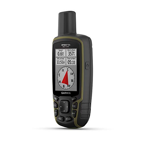
Pinpoint Accuracy: This is a precision tool for those who demand the absolute best in satellite accuracy. Its multi-band GNSS technology connects to five different satellite systems (GPS, GLONASS, Galileo, QZSS, IRNSS) simultaneously, giving you pinpoint accuracy even in deep canyons or thick forests where other devices fail.
- Multi-band GNSS technology provides superior positioning accuracy.
- 2.6-inch sunlight-readable color display.
- Features a 3-axis compass and barometric altimeter.
- Preloaded TopoActive maps with public land boundaries.
- Glove-friendly physical button controls for tactile feedback.
- Pairs with the Garmin Explore app via Bluetooth and ANT+.
Final Verdict
Choosing the best handheld GPS comes down to your needs. For straightforward, reliable navigation, the Garmin eTrex 22x is a durable and affordable workhorse. If you need advanced sensors, the eTrex 32x adds a compass and altimeter. For ultimate accuracy, the GPSMAP 65s is unmatched. And if communication is key, the inReach Mini 2 provides a compact lifeline, while the Montana 700i combines it all in one large-screen device.
| Product | Best For |
| Garmin eTrex 22x | Simple, Rugged Reliability |
| Garmin Montana 700i | Communication & Navigation |
| Garmin eTrex 32x | Advanced Sensor Data |
| Garmin inReach Mini 2 | Compact Satellite Lifeline |
| Garmin GPSMAP 65s | Pinpoint Accuracy |
Frequently Asked Questions (FAQs)
What is the main difference between the Garmin eTrex 22x and 32x?
The main difference is the sensors. The eTrex 32x adds a 3-axis compass (so you know your heading even when standing still) and a barometric altimeter (for precise elevation tracking and weather trend monitoring). The 22x relies on GPS movement for direction and GPS data for elevation.
What is inReach satellite technology?
inReach technology, found in the Montana 700i and inReach Mini 2, uses the global Iridium satellite network. It allows you to send and receive two-way text messages and trigger an interactive SOS alert to emergency services, even when you have zero cell phone service. It requires an active satellite subscription.
Why is multi-band GNSS on the GPSMAP 65s better?
Multi-band technology allows the GPS to receive signals from multiple satellite systems (GPS, GLONASS, Galileo, etc.) on multiple frequencies. This dramatically improves accuracy, especially in challenging environments like deep canyons, urban areas, or dense forests where standard GPS signals can bounce or be blocked.
Do these handheld GPS units come with preloaded maps?
Yes, all five models on this list come preloaded with Garmin’s TopoActive maps for North America. These maps provide detailed terrain, roads, and trails for activities like hiking, biking, and off-roading. You can also add more maps via the microSD slot.
What is the battery life like on these devices?
The eTrex 22x and 32x offer the best field-swappable option, with up to 25 hours on two AA batteries. The GPSMAP 65s lasts up to 16 hours in GPS mode. The rechargeable Montana 700i lasts up to 18 hours, while the inReach Mini 2 can last up to 14 days with 10-minute tracking.